Day Trips to the Las Labradas petroglyphs (GPS N23°75'40" W106°84'36") on the Sinaloa coast just north of Mazatlan
Top rated day trip excursions and popular self-guided tours of Rural Sinaloa archaeological sites and petroglyphs near Mazatlan!


Las Labradas Day Trip Info | mazatlantoday.net Travel Guide 2023 Homepage

Follow mazatlantoday.net on Instagram!
Visit mazatlantoday.net on YouTube!

Updated January 23, 2024

Contact mazatlantoday.net


Send your email and join our community!

Sightseeing Attractions

Mazatlan Mexico easy day trips Day Trips to Rural Sinaloa

Tours and Excursions

Centro Historico Walking Tour

Maps of Mazatlan Sinaloa

events • holidays

Mazatlan Carnival 2024

Spring Break Mazatlan 2024

Semana Santa Mazatlan 2024

Dia de la Independencia 2024

Day of The Dead 2024

outdoor fun • exercise

Water Sports and beach activities

Sport Fishing, ocean and lakes

Golf Courses and driving ranges

Health Clubs and outdoor sports

Bike Rental, repair, sales, tours

shopping • services

Mazatlan Shopping Guide 2023

Spas, Salons and Beauty

Veterinarians and Animal Welfare

Real Estate Guide and MLS

logistics • lodging

Mazatlan FAQ and Travel Tips

Taxis and Pulmonias

Buses: intercity, international, local

Cruise Ships Shore Excursions

Mexican Federal Highway 40 / 40D

Auto Service and Repair

WiFi Internet and Phone

health care and medical tourism

Doctors, Dentists, Pharmacies

EMS and Emergency Services Info

history • churches

Mazatlan History in English

Sinaloa History in English

Churches in Mazatlan, Mexico


INAH Sinaloa

A guide to the Las Labradas petroglyphs

Buy Glen Rogers sacred art book

Semarnat Sinaloa

Join the mazatlantoday.net Mazatlan community!

Las Labradas petroglyphs, Sinaloa, Mexico / Click for Day Trips homepageLas Labradas Petroglyphs, Sinaloa
Day Trip North / 45 miles / How to get to Las Labradas

North El Quelite | La Noria | Meseta de Cacaxtla and Barras de Piaxtla

Las Labradas Petroglyphs | San Ignacio | Lake El Salto | Cosala

Reserva Nuestra Señora Mundo Natural | Durango

South Concordia | Copala | El Rosario | Playa el Caimanero | Teacapan

Islands near Mazatlan Stone Island | Deer and Goat Islands | Bird Island

Las Labradas Sinaloa petroglyph

Download free map and directions for day trip to Las Labradas, SinaloaThe petroglyphs at Las Labradas were once one of the less- discovered Mazatlan day trips -- and one of the most inspiring when you took it. This unique archaeological site remains just as inspiring as ever, but it has become very popular!

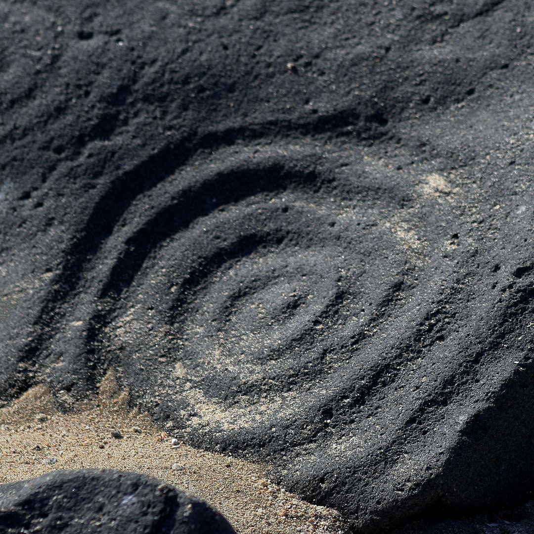
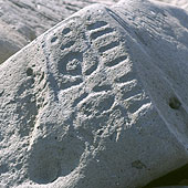
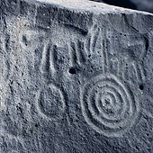
Located little more than an hour north of Mazatlan on the Sinaloa coast near the fishing village of Barras de Piaxtla, Mazatlan day trips to Las Labradas will put you on a fantastically beautiful beach with black rocks which contain petroglyphs -- stones with ancient symbolic carvings -- that reflect the spiritual life of pre-colonial Indians indigenous to Sinaloa.

This is not just a couple of rocks: roughly 640 petroglyphs dot nearly 1200 linear feet of shoreline.

The petroglyphs at Las Labradas were made by the ancestors of the indigenous Indians that the Spanish Conquistadors, encountered when they first entered Sinaloa in 1531, and are beautiful ancient artistic expressions of the pre-Columbian people of our state, as well as a gateway into their spiritual lives.

The oldest petroglyphs at the site are an astounding 4500 years old. The site was in continuous use for over 3000 years -- it was only abandoned in 1200 A.D. -- making it the oldest archaeological site in the state of Sinaloa with some of the oldest pre-Columbian art in northwest Mexico.

The Las Labradas petroglyphs are understood to be associated with the supernatural, and are believed to have been a method the Amerindians used to communicate with their gods.

Groups of Indians made long trips -- often for hunting or, as in the probable case at Las Labradas, fishing -- and these journeys are believed to have led by religious leaders.

The Las Labradas petroglyphs were most likely made made within the context of rituals and ceremonies in which priests asked their gods for benefits such as rain; a bountiful harvest; or a successful hunt.

It is believed that priests carved the Las Labradas petroglyphs, and that they represent their dreams and visions, often enabled by the use of hallucinogenics.

Spiral pattern petroglyph at Las Labradas Sinaloa MexicoLas Labradas Mexico petroglyphSpiral and line pattern petroglyph at Las Labradas Sinaloa Mexico

Video about the Las Labradas petroglyphs


INAH SinaloaLas Labradas received major recognition and major site upgrades in 2012.

INAH (Instituto Nacional de Antropología e Historia), the Mexican National Institute of Anthropology and History, officially recognized the cultural importance of Las Labradas, and made two important investments in the site.

The access road was properly graded -- it was a bit, ah, rough before -- and INAH built a lovely lovely new museum at the beach overlooking the best of the petroglyphs which replaced the cute but quite rustic palapa that stood there before.

Las Labradas is the first active archaeological site opened to public in the state of Sinaloa, and one of only 26 of the 187 archaeological sites open to public in Mexico that is officially designated as an Archaeological Monument.

Something truly different among our recommended day trips around Mazatlan, at Las Labradas you can combine a top rated Mazatlan day trip to a undiscovered beach -- despite the newfound popularity, the Las Labradas beach is often virtually completely deserted, you will probably have it all to yourself -- with an art tour of pre-Columbian Mexico!

The beach at Las Labradas Sinaloa Mexico

Las Labradas Day Trip Directions

Download free map and directions for day trip to Las Labradas, SinaloaTo begin Mazatlan day trips to Las Labradas head northwest on Highway 15. Little more than 4 miles north of town Highway 20 will split off to your left. Follow Highway 20 North for about 40 miles (before you arrive at a town called Dimas) and you will see a dirt road that splits off to your left -- directly toward the beach. Take the dirt road (passable with normal vehicles) to the beach and you will be at Las Labradas!

While Las Labradas is close to Barras de Piaxtla, the nearest town is Chicayota. On Sundays the villagers from Chicayota sell their handcrafts and local food in the INAH installations. We encourage visitors to consider buying something to help the local economy.

GPS N23°75'40" W106°84'36"

Hours Monday - Thursday 9am to 5pm, Friday - Sunday 9am to 6pm

Admission 48 pesos which includes access to the site; parking; museum admission and use of bathrooms. Cash only.

DOWNLOAD LAS LABRADAS DAY TRIP MAP AND DIRECTIONS

ACCESS ALL RURAL SINALOA MEXICO MAPS


Map to Las Labradas from Mazatlan

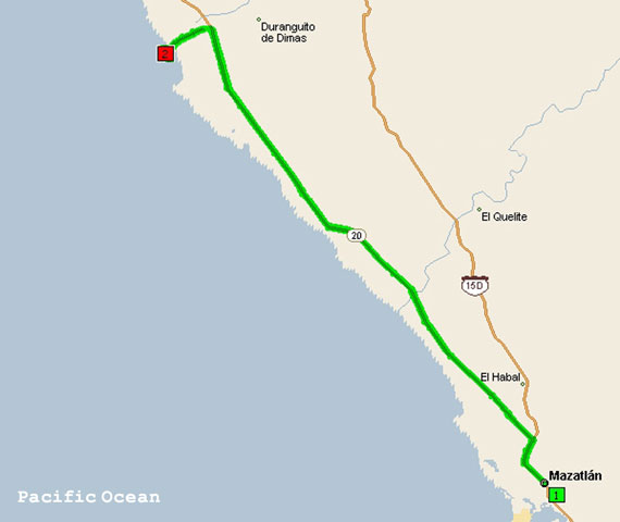
Las Labradas map from Google Maps


North El Quelite | La Noria | Meseta de Cacaxtla and Barras de Piaxtla

Las Labradas Petroglyphs | San Ignacio | Lake El Salto | Cosala

Reserva Nuestra Señora Mundo Natural | Durango

South Concordia | Copala | El Rosario | Playa el Caimanero | Teacapan

Islands near Mazatlan Stone Island | Deer and Goat Islands | Bird Island


Mazatlan to Las Labradas Petroglyph Day trips: The best places to visit and archaeology sites to tour in Rural Sinaloa with maps, directions, GPS coordinates and detailed info, descriptions and reviews


HOMEPAGE

Mazatlan Carnival 2024 - español

Spring Break Mazatlan 2024

Easter Week / Semana Santa 2024 - español

Dia de la Independencia Mazatlan 2024

Day of The Dead / Dia de los Muertos 2024


SIGHTSEEING ON MAZATLAN VACATIONS IN 2023 (español)

Centro Historico

Free Centro Historico Walking Tour - español

Plaza Machado

Angela Peralta Theater

Basilica de La Inmaculada Concepción

The Malecon

Cliff Divers

Fine Art Museum

Archaeology Museum

Pedro Infante Museum - español

Pino Suarez Market

Acuario Mazatlan Aquarium

Carpa Olivera saltwater public pool

El Faro Lighthouse

Bosque de La Ciudad central city park

Estero del Yugo nature preserve

Cruise Ship Arrivals and things to do

Tours and passenger excursions


DAY TRIP DESTINATIONS NEAR MAZATLAN (español)

El Quelite

La Noria

Meseta de Cacaxtla and Barras de Piaxtla

Las Labradas Petroglyphs

San Ignacio

Lake El Salto

Cosala

Reserva Nuestra Señora Mundo Natural

Mexican Federal Highway 40D - español

Victoria de Durango, Durango

Concordia

Copala

El Rosario

Playa Caimanero

Teacapan / Playa Espiritu

Stone Island - español

Deer and Goat Islands

Bird Island


BEACHES IN MAZATLAN (español)

Sport Fishing, ocean and Bass lake trips

Golf Courses and driving ranges - español

Bike Rental, Repair, Sales, Tours

Fitness, Exercise, Yoga

Water Sports


SHOPPING, STORES, SERVICES

Spa and Salon

Veterinarians, Pet Care and Shelters

Real Estate MLS

Pulmonia and Taxi

Bus lines, routes and terminals - español


FAQ AND 2023 TRAVEL ADVICE

Medical Care, Doctor, Dentist, Pharmacy

Emergencies and EMS

Auto Repair

WiFi and Phone

Free maps of Mazatlan and Sinaloa

History of Mazatlan

History of Sinaloa State

Churches

RESOURCES

Centro Historico Walking Tour Map - español

Beach Guide Mazatlan 2023 - español

Day of The Dead Parade Map - español

Stone Island Day Trip Map - español

Concordia Day Trip Map

Copala Day Trip Map

Cosala Day Trip Map

Durango Day Trip Map

El Quelite Day Trip Map

El Rosario Day Trip Map

La Noria Day Trip Map

Lake El Salto Day Trip Map

Las Labradas Petroglyphs Day Trip Map

Meseta Cacaxtla - Barras Piaxtla Day Trip Map

Playa el Caimanero Day Trip Map

Reserva Nuestra Señora Mundo Natural Day Trip Map

Teacapan Day Trip Map

Medical Services and Medical Tourism

City Bus Map

Map to Mazatlan Airport

Grocery Shopping words in Spanish

Emergency Services


©2009-2023 mazatlantoday.net
All Rights Reserved
Terms of Use
Sitemap
Updated 23 Jaunary 2024